Wednesday, April 30, 2008

Visited a couple of unique places today

Today we decided to go to the Road Kill Café for lunch and check it out. We heard about this café from Gideon, who owns the Woodcraft Shop that Woody frequents and I have visited, oh yeah I spent money there! At any rate, Dave said their food was not great but we wanted to check out the place just because it is different and has a reputation!

Had to stop here first though it was on the way, and not far from Dave’s house. The Alpine Pantry, a bakery/meat shop/store run by the Mennonites. Woody has been there several times to buy bacon and bread, I had not and Woody knew I would love to visit it. Their in-house bakery offers all types of bread, pies, cinnamon buns, apple dumplings, and many other delightful delectables. The bread is sliced, if you prefer, while you wait. The bacon is excellent, sliced at your request. The meat shop also offers all kinds of cheeses, and other items that one would expect to find in a meat shop. The store offers everything from home made jellies, many sugar free candy items , baking items, hand sewn aprons, bun cosies, etc., as well other items too numerous to mention. Mennonites here all dress according the old Mennonite style, ladies in long cotton dresses with bonnets; the men in black or brown pants with suspenders, a dark coloured shirt, and usually a black hat. The store is very, very clean, well kept, very nicely laid out and a real pleasure to shop in, not costly and I would recommend it to anyone. I bought some cinnamon buns with real butter icing! You just cannot walk in there and smell all the goodies, and walk out with none of them! Woody picked up bacon, which we needed.


Okay, now we are on our way!


The Road Kill Café is Born
During hunting season of 1984, Barbara Snider decided to go into business in Artemas, Pennsylvania. She had a building constructed and gasoline pumps installed and opened a grocery and gas station facility where she saw a need for just such a place. Early on, she placed a couple of picnic tables in the far side of the store and prepared food, especially homemade pies for the hunters. She has always accommodated the hunters, even their hours, and has therefore been known to open her store in the wee hours of the morning so that they would set off with a hot meal under their belts.
Later in 1995, Barbara decided to build an addition to the existing grocery store and make a restaurant. People from far and wide are familiar with the Road Kill Café in Artemas. The restaurant can accommodate eighty people at a time, and on any given Thursday, her “big” day, she estimates that they serve about five hundred customers. The food is excellent and the prices are more than reasonable. She is well known for her homemade pies, which causes her to stay up all hours on every Wednesday to bake fresh and have ready for her Thursday menu of barbecued ribs, macaroni salad, green beans as the main entrée. Folks travel long distances for a meal at the Road Kill!
The name of Barbara’s establishment came about when someone spray-painted an old barn board and stuck it up on the roof of the porch. This was before the addition of the actual restaurant, yet people were eating there on a pretty regular basis. The sign read Road Kill Café and to this day is still known as such.
Within the last couple of years, Barbara has added cabins and campsites to her line of business. These accommodations are available for anyone who reserves them, but are always full to capacity during hunting season or whenever a big local construction project is underway.

Below is the menu the cafe is known for and freely given to the patrons. I scanned it so you could enjoy it. Click on the pictures if you want an easier read, do take the time to read it, well worth the chuckle. Note: probably not a good idea to read to children that love animals though!


On the way home we took some pictures, the scenery is breath taking in this area.


We were trying to capture all the different shades of green, the sun and clouds were having a fight with the clouds winning, the light is not good.


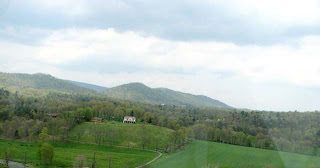
I just cannot get enough pictures of these hills and valleys, they are so gorgeous!


On the way home, Woody helped a neighbour of Dave’s out. Just as we turned onto the road leading up to Dave’s house, we encountered a fellow that was stuck, Woody stopped and helped him out, there was barely room for the truck to sneak by between the loader and the building so he could hook up and pull him out.


Woody had to drive part way into the building to actually pull the little loader out of the ditch.
Just as Woody was getting set up to pull the loader out a friend of Dave's had seen the delima from the road as he was driving by, he came up the other driveway into Dave's place (he has 2 entrances to his place) and came down to help out. Everyone in this area is so very friendly, no matter where we drive on these little country roads as people pass they will always wave or if they are out working in their yards they always wave. Of course the speed limits on the small country roads is anywhere from 20 mph to 40 mph so one is never in a hurray! We stood around visiting for a time then headed up the hill to Dave's.
As soon as we arrived home we took Oreo for a walk, then Woody took the wood he had cut from the burl on the tree over to the shop to be cut into usable size pieces. Dave had arrived home while we were walking Oreo so upon Woody’s return he and Dave worked on the bow and arrows.
The cutline you see on the hill (across the field) divides PA and Maryland, we are on the PA side. Just past the green field is Flintstone Creek, from our vantage point we can hear it running such a peaceful sound. Flintstone Creek is heavily fished, we always see vehicles stopped in all the little pull outs.
Hey just one more picture before we return home from our walk!
I of course could not wait to download the pics and get them ready to upload to the blog. Woody returned home all excited, the bow was just about ready for a try out. It wasn’t much longer and Dave came knocking on the side of the fifth, hollering through the window, “Can Woody come out to play”? Dave is such a character! Of course, they went out to try the bow! Woody loves it, although they found some fine tuning still needs to be done, which they expected to be the case. Woody also says that he will have to practice lots to be ready for his Africa trip. We finished the evening off visiting friends in our favourite chatroom.

Tuesday, April 29, 2008

Aother hunting day

Woody and Dave went Turkey hunting today to no avail. Saw and heard them but they had hens with them and wouldn’t come in! They did bring back more Morel mushrooms though, they sure are good eating, considered a delicacy here, very expensive to purchase at any store, and they grow quite abundantly around here in the bush if you know just where to look.
It is cool here today in the 40’s with a breeze and some sun.
Our email has been down since Friday morning. Hughes sent us notification that the email service would be upgraded; we would not have access to our email Friday 6:00 pm to 6:00 AM Saturday. The notification kept changing over the course of the next few days, Hughes then decided to do a roll back to previous version as of today we still cannot access our email, BLAH! Technology is wonderful until it doesn’t work. I feel for the tech people working at Hughes though, not fun when things go wrong and the pressure is on! We are spoiled this trip, had internet connections the whole trip either WiFi or our dish is set up. The trip we made in 2006 we chose not to take the dish and only had WiFi at a couple of stops; we missed not being connected but got used to it very quickly.
After lunch the boys worked on Woody’s arrows and setting up his bow, (Dave is a bow tech). He is setting up a bow he gave to Woody for his trip to Africa in June and I went with Randi to the market (yes Randi finally had a day off), we then had dinner at Dave’s, visited for awhile and spent the rest of the evening quietly at home.

Monday, April 28, 2008

Rain, Rain, go away! Maryland Information

Dave and Woody planned on Turkey hunting, woke up to pouring rain, which continued most of the day so no hunting today!
We spent a quiet day, Woody did some shopping, I spent the day working on the blog, and then we visited with Randi and Dave for the evening. Nothing exciting but we enjoyed our day.

Thought I would add some information on Maryland seeing as we are living right next to it and shop there all the time.
Maryland was the 7th state in the USA; it became a state on April 28,1788.
State Abbreviation - MD
State Capital - Annapolis
Largest City - Baltimore
Area - 12,407 square miles [Maryland is the 42nd biggest state in the USA]
Population - 5,600,388 (US Census 2005 estimate) [Maryland is the 19th most populous state in the USA]
Name for Residents - Marylanders
Major Industries - farming (corn, soybeans, tobacco, poultry and dairy products), mining (coal), steel products, communications equipment, fishing (crabs and oysters), government services
Major Rivers - Potomac River, Patapsco River, Patuxent River, Susquehanna River
Major Lakes - Lake Oakland, Deep Creek Lake, Prettyboy Reservoir, Loch Raven Reservoir
Highest Point - Backbone Mountain - 3,360 feet (1,024 m) above sea level
Bordering Bodies of Water - Chesapeake Bay, Atlantic Ocean
Origin of the Name Maryland - Maryland was named to honor the Queen consort Henrietta Maria (1609-1669), the wife of Britain's King Charles I
State Nickname - Old Line State
State Motto - "Fatti Maschii, Parole Femine" Manly Deeds, Womanly Words
State Song - Maryland, My Maryland
State Flag
Officially adopted by law on March 9, 1904, the Maryland State Flag is the only state flag based on heraldic emblems. The design of the flag is taken from the shield in the coat of arms of the Calvert family, the colonial proprietors of the state of Maryland. The coat of arms adopted by George Calvert, the first Lord Baltimore, included a shield that combined the yellow and black colors of his paternal family and the red and white colors of his maternal family, the Crosslands. (NOTE: There is contention that the red and white colors identified as those of the Crosslands is a misrepresentation. It is said that the colors are those of the Mynne family, the family name of Anne Calvert, wife of George Calvert.)

The Official Maryland State Seal The seal of the state of Maryland is a symbol of the authority and sovereignty of the state and is a valuable asset of its people.
State Flower-Black-eyed susan Rudbeckia hirta
The Black-Eyed Susan (Rudbeckia hirta) has been the official Maryland flower since 1918 when it was designated the "Floral Emblem" of Maryland by the General Assembly (Chapter 458, Acts of 1918; Code State Government Article, sec. 13-305).
State Bird
The Baltimore Oriole (Icterus galbula) was adopted by and act of the Maryland General Assembly in 1947. Special provisions were made for the bird's protection as well.
State Tree: White Oak (Legislation of 1941)

An American Champion:
Maryland's Wye Oak
The fate of the Wye Oak on the Eastern Shore of Maryland was inevitable due to its venerable age and gradual decline. By the end of the twentieth century its massive core was hollow. The high winds of June 6, 2002, finally toppled the famous giant. From 1939 it was the centerpiece of the Wye Oak State Park, four acres which protected the tree's nearly half acre spread. Recent measurements placed the Wye Oak at over 31 feet around and 96 feet tall.

Above: Wye Mills Oak, near Wye Mills, Talbot County, Maryland, on concrete road about 9 miles from Easton, Maryland. According to the tablet at root of tree, the Wye Oak was 375 years old in 1921. DBH 6 ½ feet; horizontal spread of branches, 140 ½ feet; height, 88 feet; largest limb, diameter 2 ½ feet. 1937.
The rockfish (Morone saxatilis) was named the official fish of the State of Maryland in 1965 (Chapter 513, Acts of 1965; Code State Government Article, sec. 13-304). Originally called Roccus saxatilis, scientists corrected the genus designation in the late 1960s.
Maryland State Gemstone: Patuxent River Stone (Legislation of 2004)

Saturday, April 26, 2008

Woody and I went to church with Dave poor Randi had to work. During the church service, Dave sang a duet, which Woody videotaped. The videotape turned out well and I will make a DVD for Dave, a copy for us, including songs that he had previously taped. Dave has a superb singing voice. After church we went for a drive to view two PA dams that are close by. One dam is very old; the other supplies the drinking water for Cumberland. Didn’t take any pics, didn’t have the camera along. We hope to go back another day and get some pictures. After Randi returned from work, we went out for dinner to the Red Lobster in Hagerstown, MD, celebrating our Anniversary.


Woody ordered a bottle of wine to complement our dinner.
What could be better than celebrating our special day with good friends!
Oh yeah the food was excellent!
A very enjoyable dinner shared with friends, how lucky we are!
During the drive home Dave sang “Wind Beneath My Wings” for us (a song that has special meaning for us), also a song which Dave sang to us over the phone on a previous anniversary. In addition, he sang some Kenny Roger tunes and others. Thank you Dave and thanks to Randi for playing DJ and supplying the music.
We had a wonderful trip home and will remember this very special anniversary celebration always.
Overall it was a stupendous day!

I toured, Woody went hunting

Woody went Turkey hunting with his buddy, they heard many turkeys gobbling, and not one would come close enough to give them a glimpse. After lunch, Woody and Dave did some yard work and other chores.
Ellie (Dave’s sister) was kind enough to invite me out for an afternoon of sightseeing in Cumberland, she picked me up at 11:00 and off we went. The day was nice warm and sunny, perfect for being out and about. First Ellie drove me around so I would have an idea of what there was to see and then we picked some places to stop and investigate further. The city has a lot to offer with many beautiful old buildings, and of course is outstanding just the way it is tucked into the hills with many narrow hilly winding streets. Parts of the old city are in the process of restoration and other areas completely restored. The city definitely has colonial history and Victorian charm.

A little history of Cumberland

Cumberland, Maryland is named after the son of King George II, Prince William, the Duke of Cumberland. It is built on the site of the old Fort Cumberland, a launch pad for British General Edward Braddock's ill-fated attack on the French strong-hold of Fort Duquesne (located on the site of present-day Pittsburgh) during the French and Indian War.

Cumberland was also an outpost of Colonel George Washington during the French and Indian War and his first military headquarters was built here. Washington later returned to Cumberland as President in 1794 to review troops that had been assembled to thwart the Whiskey Rebellion.
Cumberland was a key road, railroad and canal junction during the 1800s and at one time the second largest city in Maryland (second to the port city of Baltimore--hence its nickname "The Queen City"). The surrounding hillsides provided coal, iron ore, and timber that helped supply the Industrial Revolution. In addition, the city was a major manufacturing center, with industries in glass, breweries, fabrics, and tinplate. However, following World War II, it began to lose much of its industrial importance and its population declined from 39,483 residents in the 1940 census to fewer than 22,000 today. Similar to other communities it resembles in the Monongahela Valley Industrial region of southwestern Pennsylvania, the city continues to struggle with the challenges of transitioning to a post-industrial economy.

The Headquarters of George Washington is all that is left of Fort Cumberland other than some of the wall that was built to protect the Fort.


We could not go inside (not open) but we did peek through the window; the inside is an exact replica with mannequins and all.


The building was moved from it's original place in Ft. Cumberland as you can read.


Some pics of Riverside Park.


We then wandered over to view the Wills Creek/Potomac River and canal.


Wills Creek is a tributary of the North Branch Potomac River in Pennsylvania and Maryland. Wills Creek drops off the Allegheny Mountains of southeastern Somerset County, Pennsylvania, and enters the North Branch Potomac River at Cumberland.


In the 1950's, the city of Cumberland, and the United States Army Corps of Engineers embarked upon an 18.5 million dollar flood control program along a stretch of Wills Creek bordering the city. The project was one of the most costly public works project in the city's history. Disastrous floods from Wills Creek have ravaged Cumberland over the years, particularly in 1924, 1936, and 1942, and the Army Corp of Engineers was called upon to design a system that would prevent property damage caused by high waters. It began just upstream from the Route 40 Bridge, where the corps paved the bottom of Will’s Creek, constructing concrete walls along its banks, and implementation of a sophisticated pumping system to prevent the watershed from flooding during heavy rain. The work took a decade to complete, being finished in 1959, and has successfully prevented flooding ever since.


We then visited the Scenic Western Maryland Railroad train station that is part of Canal Place. Canal Place is a 58.1 acre park operated by the National Park Service . The park includes the Western Maryland Railway Station, Station Plaza, a picnic area, a canal boat replica, a pedestrian bridge to Washington’s Headquarters, picnic area, and the Crescent Lawn Festival Grounds.
Woody and I are planning to take the scenic ride before we leave.

The Western Maryland Scenic Railroad is a heritage railroad based in Cumberland. It operates over ex-Western Maryland Railway trackage to Frostburg, Maryland and back using both steam and diesel locomotives.
The WMSR operates passenger excursion trains out of the former Western Maryland station in Cumberland, which also houses one of the six visitor centers of the Chesapeake and Ohio Canal National Historical Park as well as other attractions and offices. This station was built in 1913.
The line proceeds northwest through "the Narrows", a deep gorge formed by the passage of Wills Creek between Haystack Mountain and Wills Mountain The train then proceeds up the Allegheny Front through a water gap formed by Jennings Run, past Mt. Savage and terminates at the former Cumberland and Pennsylvania Railroad depot in Frostburg, which now houses a restaurant. The train lays over here to allow visiting the town, and the locomotive is turned on a turntable before the train returns to Cumberland.
Intermediate sights on the line include:

Helmstetter’s Curve in Cash Valley
Brush Tunnel
Woodcock Hollow, site of a hairpin curve

Normal power for the train is ex-Lake Superior and Ishpeming #734, a 1916 Baldwin-built 2-8-0 painted in WM "fireball" livery. The locomotive came to the line from the Illinois Railroad Museum, which sold it to the WMSR in 1991. After an extensive rebuild the WMSR crew put it into service in 1992; it has received several modifications over the years to give it more of a WM appearance. In addition the WMSR has two ex-Conrail GP30s (501 being former PRR, 502 being former Reading) which are used as helpers for the steam locomotive and as power for short excursions run for special events.
In addition to coach and first class service, it is possible to reserve caboose and cab rides. The railroad also runs murder mystery excursions and special seasonal trips.

After visiting the Railway station, we took a stroll up Washington Street the hub of Cumberland society in the early days.


This building is the Public Library.


I took some pics of some houses along the street. We only walked up a portion of Washington Street, the homes where the very rich elite society lived were further up the street, we only drove by!


These homes belonged to the moderately rich elite society!

Many of the homes have interesting turrets.


Others used interesting inlays.


The city also has many beautiful old churches.

This being the most intersting with all the history attached to it. I included just a little of the history.


Emmanuel Episcopal Church in Cumberland, Maryland sits on a high bluff, commonly referred to as "Fort Hill," overlooking the area where Wills Creek enters the Potomac River. Fort Hill is the site of old Fort Cumberland, which became a crown fort in April 1755. Fort Cumberland provided safety for the settlers on the western boundaries of Maryland and Virginia during the French and Indian Wars. Confrontations between the French and the British began in 1754 when the British settlers began to expand into the Ohio Valley, which was already occupied by the French trading with Native Americans. These confrontations escalated until May 18, 1756 when a formal declaration of war was made by the British. This war was called the Seven Years War in Europe and the French and Indian Wars in the Colonies.

A closer view.


Emmanuel Church, standing at the eastern end of the Washington Street Historic District, is one of Maryland's most outstanding examples of early Gothic Revival architecture. The church is situated on the former site of Fort Cumberland, and earthwork tunnels remaining from the fort run under the church. The church was constructed around 1850 and designed by well-known Philadelphia architect John Notman. It is modeled after St. Paul's Church in Brighton, England. The design is typical ecclesiastical architecture of the second quarter of the 19th century, especially that of the Episcopal Church. The pictures of this church I copied from a Website.

I should have used the wide angle lense for this picture but didn't bring it along! The tower is longer than it appears to be in the pics.


The Cumberland Narrows is a compact notched valley that Wills Creek has carved into Wills Mountain. The National Highway (Route 40) and numerous railroad lines pass through this steep, narrow, and rocky river valley on the edge of Cumberland, On the northeast side of Wills Mountain, sits a rocky outcropping known as Lover's Leap. The name comes from a Native American Romeo and Juliet legend. The tale tells how a jilted lover met his end by jumping off this ledge. Today, the rocks high above the water provide one of the most breathtaking views in the Allegheny Mountains. Postcard pictures of this valley have frequently romanticized lover’s leap. The most famous post cards were taken by George Steward in 1950 and published in the 1953 book, U.S. 40.
Lover's leap is 1,652 feet above sea level and made up of oddly squared trajectories of rock, from its top, all the way down to the National Highway (U.S. Rte. 40) below. The City of Cumberland and the surrounding states of Pennsylvania and West Virginia may be seen from this point. Further, it is known that the air currents whipping up and around are so strong, that a climber cannot be heard from the top once over the lip, nor can be easily seen due to the projected rock angles.

This pic and the one of the Narrows was taken from Constitution Park, which is the main area for the swimming pool, ball park, etc.
Upon our return from sightseeing Ellie, Dave, Woody and I sat in the shade (under Dave's carport) and visited for awhile. Randi was working. Ellie left, Randi arrived home just before a wild thunder storm rolled through, lots of water came down, a torrential downpour, over 2 inches of rain in 1/2 hour in some places. When the rain let up we hurried to our little home, made some dinner, visited friends in our favourite chatroom, and shared the happenings of our day. Another extraordinary day!

Some information on the Province we hail from

A few facts on the Province of Alberta for our friends that we meet along the road in our travels or others that read our blog just for fun.

The population of Alberta is 3,455,062--2003 Stats.

Land area-248,000 sq. miles

Alberta’s climate is highly variable. Summer typically runs between May and September, days are warm and evenings are cool. Winters are cold with heavy snowfalls, particularly in the Rocky Mountains.

The largest cities are Edmonton and Calgary.-More than half of the people live in these two cities. Immigrants came from Britain, Western Europe, Eastern Europe, the East and Southeast Asia.
Ethnic backgrounds - British (44 percent), German, Ukranian, French, Scandinavian, Dutch, and many other countries.

Some history on Edmonton, Capital of Alberta, Population, 730,372-2006 Stats
5.000 years before European explorers and fur traders arrived in the Edmonton area, the land was populated by various Tribal Nations. In 1795, the Hudson's Bay Company established its first trading post near the present site of Fort Saskatchewan in order to trade fur with First Nations. The fort was moved several times, to be settled permanently in 1830 on land that is today known as Alberta Legislature Grounds. The fur trade boomed for many decades. In 1870, the Canadian government bought the land from the Hudson's Bay Company to open it for settlement. In 1892, Edmonton was incorporated as a town. At this time, about 700 people called Edmonton their home. In 1898, the Gold Rush Edmonton became the outfitting center for many prospectors heading for the Yukon. By 1904, Edmonton had a population of 8,350. Soon after, when Alberta joined the Confederation, Edmonton was selected as provincial capital. In 1908, the University of Alberta opened its doors. Edmonton entered a frantic boom period when Strathcona amalgamated with Edmonton in 1912, combining their population to over 40,000. In the 1930s Edmonton became the "Gateway to the North" flying medical supplies, food and mail to remote northern communities. Edmonton's face changed forever when oil was discovered in Leduc in 1947. Overnight Edmonton became the Oil Capital of Canada and Edmonton's population doubled within a decade. Still today, the oil and gas industry remains the city's economic cornerstone. The 1960s brought the Edmonton International Airport, the Citadel Theatre, the 27-story CN Tower and the Provincial Museum of Alberta. The 1970s brought a further boost to development of Edmonton and the Northlands Coliseum (today Skyreach Centre) opened its doors to mark the NHL's best ice surface. In 1978, Edmonton became the first city with a population smaller than 1 million to have a Light Rail Transit (LRT) system. With the opening of West Edmonton Mall in 1981, Edmonton entered the Guinness Book of Records with the world's largest shopping and entertainment complex. In 1995, Edmonton celebrated its 200th year.

HISTORY-The first people were the: Slavey, Chipewyan, Kootenay, Beaver, Cree, Sarcee, Blood, Piegan, Gros Ventre and Blackfoot.
  • In the north they hunted moose, caribou and deer, fished and gathered plants and berries. They used bark canoes to travel up and down the streams.
  • On the plains they hunted the bison and lived in teepees.
  • Anthony Henday ( European explorer and fur trader ) came to Alberta in 1754.
  • Fur traders built trading posts on the Athabasca River and North Saskatchewan River.
  • Forts were built to keep law and order.
  • The First Nations traded furs and received guns, blankets and metal goods.
  • Alberta grew when the railroad was built in 1883. Early settlers were ranchers from England and the United States. Immigrants came from Ukraine and many parts of Europe to farm.
  • The main rivers are the Peace River, North and South Saskatchewan River, and Athabasca River.
  • There are icefields in Banff and Jasper National Parks.The icefields help to fill the rivers.
  • There are five national parks.Banff National Park is the oldest national park in Canada.Wood Buffalo National Park is the home to about 2200 wood buffalo (endangered).
  • A large mountain range ( Rocky Mountains ) is along the western border. The badlands ( dry, sandy, rocky area) are in southeastern Alberta. Northern Alberta is covered with forest and muskeg. The rest of the province is on a great plain or prairie.

Alberta is one of the three prairie provinces. It is the fourth-largest province. Saskatchewan is east of Alberta; British Columbia is west. The Northwest Territories are north of Alberta. The state of Montana is south. Alberta was named after Princess Louise Caroline Alberta of Britain. Alberta's motto - "strong and free". Alberta is known as Canada's "energy province".

Official Song
Alberta
The official song pays musical tribute to the province’s geography, industry, history and cultural diversity. Alberta was composed by Mary Kieftenbeld as part of a contest to find an original official song in time for the province’s Centennial in 2005.

Alberta Tartan
The colours represent the following:
Green - Alberta’s forests
Gold - Alberta’s wheat fields
Blue - Alberta’s clear skies and sparkling lakes
Pink - Alberta’s wild rose
Black - Alberta’s coal and petroleum.
(adopted 1961 due to the efforts of the Edmonton Rehabilitation Society for the Handicapped, now Goodwill Industries). Dress Tartan
The Alberta Dress Tartan complements the Alberta Tartan and can be worn for dancing, special occasions and formal attire. It includes the same colours as the Alberta Tartan and adds large sections of white, a symbol of Alberta’s clean bright snowy days.
(adopted 2000)

The provincial flag was adopted on June 1, 1968 and displays the shield of arms of Alberta on a blue background. The flag is proportioned twice as long as it is wide, with the shield in the center at seven-elevenths of the width of the flag.

Wild Rose is the Provincial Flower
You don't have to search far to find the official flower of Alberta, the Wild Rose. This beautiful flower grows throughout Alberta and other regions in Western Canada. This prolific pink flower with prickly branches produces a rubbery berry known as rosehip, picked late in summer by jam makers and homemade tea producers. Rich in vitamin C, rosehips are used to fight the common cold and many types of infections, most commonly, bladder infections. Natives used them for many of the same reasons but applied them topically to the infected area in the form of a poultice. The Wild Rose became the official flower of Alberta in 1930.


Rocky Mountain Bighorn Sheep is the Provincial Mammal
The Rocky Mountain Bighorn Sheep was designated the official mammal of Alberta on August 18, 1989. Most impressive are the males with great horns that curl backwards up to 360 degrees. Prehistoric remains have been found in most of the river valleys across Alberta, suggesting that at one time enormous herds of Bighorn Sheep zig-zagged across the province. Today, the Bighorn is found mostly on grassy slopes in the Rockies. or along the shoulder of the province’s highways.

Lodgepole Pine is the Provincial Tree. The Lodgepole pine has a very flexible wood that was once used by the native people to build tepees and lodges, hence its name. It grows 30 to 35 metres high and lives for 200 years. Its needles are strongly twisted. Its cones have scales with a curved prickle that is held closed by a resin bond. To open, the cones need to be exposed to intense heat from a wildfire or from direct sunlight. Most pure stands are therefore established on burn areas. The lodgepole pine is found in western Canada and the northwestern United States. Its wood is soft to moderately hard and light yellow in colour.


The provincial bird is the Great Horned Owl. A year-round resident of Alberta, the Great Horned Owl is identified by its prominent "horns" which are actually tufts of feathers. The Great Horned Owl has acute hearing as well as binocular vision, giving them excellent depth perception.


Grass
Rough Fescue, Festuca scabrella
Alberta has the largest area of rough fescue grassland in the world and is the only place in North America that hosts the plains, foothills and northern kinds of rough fescue. Rough fescue provides excellent year-round forage for wildlife and livestock, and is a symbol of Alberta’s prairie heritage and the need for the conservation of our rich biodiversity of native grasslands.
(adopted April 30, 2003 due to the efforts of the Prairie Conservation Forum).
Stone
Petrified Wood
Commonly found in gravel pits throughout Alberta, petrified wood is the result of the deposit of microcrystalline quarts in the pores and cells of the fallen trees of the Cretaceous and Paleocene times, 60 to 90 million years ago.(adopted 1977 due to the efforts of the Alberta Federation of Rock Clubs)

Blog Archive